About the Project
Working Together in a Good Way to Find Innovative Ways to Preserve and Memorialize Indian Residential School Sites in Alberta
Why Digitally Preserve Indian Residential Schools?
Surviving Indian Residential schools are physical reminders of an education system, in name only, that caused great harm and suffering to generations of Indigenous people in Canada. Over the years, many former schools and associated buildings have been lost to fire or left to fall into varying states of disrepair. Finding ways to preserve those few that remain standing will help ensure that the history and legacy of Indian Residential Schools is not forgotten.
This community guided project explores how digital technology can be used to commemorate three former Indian Residential Schools in Alberta: Old Sun Indian Residential School on the Siksika Nation, the Edmonton Indian Residential School Carriage House in St. Albert, AB, and Blue Quills Indian Residential School in St. Paul, AB.

Old Sun Community College and University nuhelot’ine thaiyots’i nistameyimâkanak Blue Quills currently operate within two former residential school buildings, and symbolize their powerful transformation from institutions of coercive colonial tutelage to ones of Indigenous cultural revitalization. Advisory groups comprised of staff members, knowledge keepers, and former students from all three schools have partnered with researchers from the University of Calgary to digitally capture and document their respective buildings and surrounding grounds. All of this work has been done in a good way through ceremony and with culturally appropriate support available for participants.
What is Digital Preservation and How does it Work?
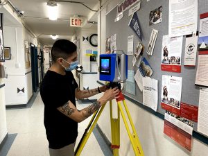
Reality capture is a term used to describe the documentation of objects and landscapes using sensors on the ground and in the air. Reality capture technologies include terrestrial and aerial laser scanning and photogrammetry.
Terrestrial laser scanners are used extensively in geomatics engineering for creating highly accurate 3D data sets for the purpose of documentation and analysis. The instrument collects millions of 3D measurement points by a process known as laser range finding. The result is a dense set of points called a point cloud that accurately and precisely defines the surface of any object within the instrument’s field of view.
Like a camera, the laser scanner can only capture what it can see. Therefore, the instrument must be moved around and through an object or scene and the subsequent scans “stitched” together using a process known as registration. A network of targets or monuments is often used to aid the registration process. Targets placed on tripods are strategically distributed throughout the scene. By identifying targets that are common to two or more scans, an operator can align and register them together to create a single 3D image. Sub-millimeter levels of precision can be attained but vary depending on the number and distribution of targets, and whether they are georeferenced or not. Cloud to cloud registration of scans eliminates the need for a targeting network. Whilst it can generally provide high registration precision, accuracy may be lower. One of the many of laser scanning for heritage preservation is the speed at which data can be captured. Depending on the level of resolution required, scans can take anywhere from 4 to 8 minutes to complete.
How were these three former Indian Residential Schools Digitally Captured?
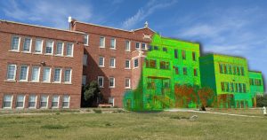
Old Sun Community College was digitally documented over a period of two weeks during the month of August 2020. The team consisted of graduate students and faculty from the University of Calgary (Archaeology, Geomatics Engineering) and three students from Old Sun Community College. Three laser scanners were used: a Z + F 5010X, a Z + F 5016; and a Leica BLK360. Working on separate floors of the school, team members would scan every room and associated space. Over 350 scans were then registered together to create a single 3D point cloud of the entire building.
Poundmaker’s Lodge Carriage House was documented over a period of two days during October 2020. Unlike Old Sun and UnBQ, this building is not currently in use and is therefore in a poorer state of condition. Smart Lights mounted on the scanners allowed us to capture the dark interior rooms which could not otherwise be illuminated due to an absence of power. The lack of heat also reduced the battery life for each scanner.
University nuhelot’ine thaiyots’i nistameyimâkanak Blue Quills was scanned during the summer of 2021. The largest of the three schools, UnBQ was captured over a period of one week by teams working with four laser scanners – including a new hand held mobile scanner called a Geo Slam Horizon.
What will be done with the Digital Data?
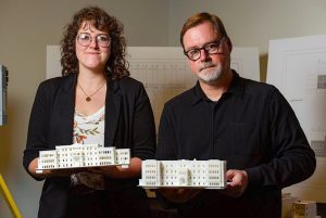
• Creation of 3D printed models and computer reconstructions of each school for use in education and public outreach concerning residential school history.
• Construction of Building Information Models (BIM’s) and architectural plans of each school from the scanning data to aid in renovation, repair, and reconstruction work.
• Online archiving of the laser scanning datasets with metadata at locations including: The Taylor Family Digital Library, University of Calgary; National Center for Truth and Reconciliation, Old Sun Community College, and University nuhelot’ine thaiyots’i nistameyimâkanak Blue Quills.
Other Archives
Please check out our other digital heritage archives!
Alberta Digital Heritage Archive
Qikiqtaruk/Herschel Island Digital Heritage Archive
If you have any questions about the archive, please reach our to archive director Dr. Peter Dawson pcdawson@ucalgary.ca